
Make a donation
Bend topographic map
Click on the map to display elevation.
Make a donation
Bend
The Deschutes River runs through Bend, where it is dammed to form Mirror Pond. Bend's elevation is 3,623 feet (1,104 metres) above sea level. The city has a total area of 33.27 square miles (86.17 square kilometres), of which 33.01 sq mi (85.50 km2) is land and 0.26 sq mi (0.67 km2) is water.
Make a donation
About this map
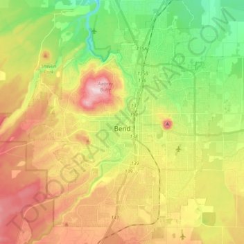
Name: Bend topographic map, elevation, terrain.
Location: Bend, Deschutes County, Oregon, United States (43.99906 -121.38243 44.12375 -121.24335)
Average elevation: 1,121 m
Minimum elevation: 985 m
Maximum elevation: 1,286 m
Make a donation
Other topographic maps
Click on a map to view its topography, its elevation and its terrain.
Three Sisters
United States > Oregon > Deschutes County
The Three Sisters are closely spaced volcanic peaks in the U.S. state of Oregon. They are part of the Cascade Volcanic Arc, a segment of the Cascade Range in western North America extending from southern British Columbia through Washington and Oregon to Northern California. Each more than 10,000 feet (3,000 m)…
Average elevation: 2,526 m