
Make a donation
Vijayawada topographic map
Click on the map to display elevation.
Make a donation
Vijayawada
Vijayawada lies on the banks of Krishna river, covered by hills and canals. and at an altitude of 11 m (36 ft) above sea level. Three canals originating from the north side of the Prakasam Barrage reservoir — Eluru, Bandar, and Ryves — flow through the city.
Make a donation
About this map
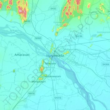
Name: Vijayawada topographic map, elevation, terrain.
Location: Vijayawada, NTR, Andhra Pradesh, 520001, India (16.34876 80.45851 16.66876 80.77851)
Average elevation: 36 m
Minimum elevation: 7 m
Maximum elevation: 447 m
Make a donation
Other topographic maps
Click on a map to view its topography, its elevation and its terrain.
Make a donation
Make a donation
Make a donation
Make a donation
Make a donation
Prakasam
The Nallamalas and the Veligondas are the major hill ranges in the district. The Nallamalas consist of a range of continuous fairly steep hills with an average elevation of about 620 meters above sea level. There are two passes in the Nallamalas namely, the Nandi Kanuma and Manbala Kanuma. The Nandi Kanuma…
Average elevation: 204 m
Make a donation