
Make a donation
Fairfax County topographic map
Click on the map to display elevation.
Make a donation
Fairfax County
Most of the county lies in the Piedmont region, with rolling hills and deep stream valleys, such as Difficult Run and its tributaries. West of Route 28, the hills give way to a flat, gentle valley that stretches west to the Bull Run Mountains in Loudoun County. Elevations in the county range from near sea level along the tidal sections of the Potomac River in the southeast portion of the county to more than 500 feet (150 m) in the Tysons area.
Make a donation
About this map
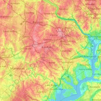
Name: Fairfax County topographic map, elevation, terrain.
Location: Fairfax County, Virginia, United States (38.60395 -77.53707 39.05771 -77.04055)
Average elevation: 75 m
Minimum elevation: -3 m
Maximum elevation: 168 m
Make a donation
Other topographic maps
Click on a map to view its topography, its elevation and its terrain.
Deep Creek
United States > Virginia > Accomack County
It lies at an elevation of 3 feet.
Average elevation: 1 m
Make a donation
Forest Hill Park
United States > Virginia > Williamsburg (city) > Williamsburg > Forest Hill Park
Average elevation: 22 m
Make a donation
Make a donation