Geolocate

Spaarndam topographic map

Click on the map to display elevation.

About this map

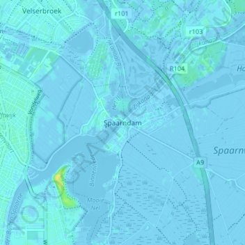
Name: Spaarndam topographic map, elevation, terrain.

Location: Spaarndam, Haarlemmermeer, North Holland, Netherlands, 2064 KX, Netherlands (52.39280 4.66201 52.43280 4.70201)

Average elevation: 0 m

Minimum elevation: -7 m

Maximum elevation: 18 m

Other topographic maps

Click on a map to view its topography, its elevation and its terrain.

Amsterdam

Netherlands > North Holland

Amsterdam is located in the Western Netherlands, in the province of North Holland, the capital of which is not Amsterdam, but rather Haarlem. The river Amstel ends in the city centre and connects to a large number of canals that eventually terminate in the IJ. Amsterdam's elevation is about −2 m (−6.6 ft)…

Average elevation: 0 m

Haarlem

Netherlands > North Holland > Haarlem

Average elevation: 3 m

IJmuiden

Netherlands > North Holland

Average elevation: 6 m

Amsterdam

Netherlands > North Holland

Amsterdam is located in the Western Netherlands, in the province of North Holland, the capital of which is not Amsterdam, but rather Haarlem. The river Amstel ends in the city centre and connects to a large number of canals that eventually terminate in the IJ. Amsterdam's elevation is about −2 m (−6.6 ft)…

Average elevation: 0 m

Muiderberg

Netherlands > North Holland

Average elevation: 1 m

Haarlem

Netherlands > North Holland

Average elevation: 3 m

Sint Pancras

Netherlands > North Holland

Average elevation: 1 m

IJmuiden

Netherlands > North Holland

Average elevation: 6 m

Diemen

Netherlands > North Holland

Average elevation: 1 m

Amsterdam

Netherlands > North Holland

Amsterdam is located in the Western Netherlands, in the province of North Holland, the capital of which is not Amsterdam, but rather Haarlem. The river Amstel ends in the city centre and connects to a large number of canals that eventually terminate in the IJ. Amsterdam's elevation is about −2 m (−6.6 ft)…

Average elevation: 0 m

Lisserbroek

Netherlands > North Holland

Average elevation: -2 m

Haarlem

Netherlands > North Holland

Average elevation: 3 m

Zwanenburg

Netherlands > North Holland

Average elevation: -3 m

IJmuiden

Netherlands > North Holland

Average elevation: 6 m

Zaandam

Netherlands > North Holland

Average elevation: 0 m

Alkmaar

Netherlands > North Holland

Average elevation: 0 m

Enkhuizen

Netherlands > North Holland

Average elevation: 0 m

Amsterdam

Netherlands > North Holland

Amsterdam is located in the Western Netherlands, in the province of North Holland, the capital of which is not Amsterdam, but rather Haarlem. The river Amstel ends in the city centre and connects to a large number of canals that eventually terminate in the IJ. Amsterdam's elevation is about −2 m (−6.6 ft)…

Average elevation: 0 m

Velsen-Zuid

Netherlands > North Holland

Average elevation: 4 m

Breezand

Netherlands > North Holland

Average elevation: 0 m

Klet

Netherlands > North Holland > Broek op Langedijk

Average elevation: 0 m

Oudkarspel

Netherlands > North Holland

Average elevation: 0 m

Bloemendaal

Netherlands > North Holland

Average elevation: 8 m

Texel

Netherlands > North Holland

Average elevation: 0 m

Petten

Netherlands > North Holland

Average elevation: 1 m

Bussum

Netherlands > North Holland

Average elevation: 5 m

Schoorl

Netherlands > North Holland

Average elevation: 3 m

Nieuw-Vennep

Netherlands > North Holland

Average elevation: -4 m

Haarlem

Netherlands > North Holland

Average elevation: 3 m

Aerdenhout

Netherlands > North Holland

Average elevation: 6 m

Marken

Netherlands > North Holland

Average elevation: 0 m

Amsterdam

Netherlands > North Holland

Amsterdam is located in the Western Netherlands, in the province of North Holland, the capital of which is not Amsterdam, but rather Haarlem. The river Amstel ends in the city centre and connects to a large number of canals that eventually terminate in the IJ. Amsterdam's elevation is about −2 m (−6.6 ft)…

Average elevation: 0 m

Aalsmeer

Netherlands > North Holland

Average elevation: -2 m

Aalsmeer

Netherlands > North Holland

Average elevation: -2 m

Blaricum

Netherlands > North Holland

Dutch Topographic map of the municipality of Blaricum, June 2015.

Average elevation: 4 m

Haarlem

Netherlands > North Holland > Haarlem

Average elevation: 3 m

Bloemendaal

Netherlands > North Holland

Average elevation: 3 m

Zaan

Netherlands > North Holland > Zaandam

Average elevation: 2 m

Abbekerk

Netherlands > North Holland

Average elevation: -2 m

Uithoorn

Netherlands > North Holland

Average elevation: -3 m

Den Helder

Netherlands > North Holland

Dutch Topographic map of Den Helder (town), March 2014.

Average elevation: 0 m

Amsterdam

Netherlands > North Holland

Amsterdam is located in the Western Netherlands, in the province of North Holland, the capital of which is not Amsterdam, but rather Haarlem. The river Amstel ends in the city centre and connects to a large number of canals that eventually terminate in the IJ. Amsterdam's elevation is about −2 m (−6.6 ft)…

Average elevation: 0 m

Amstelveen

Netherlands > North Holland

Average elevation: -2 m

Haarlemmermeer

Netherlands > North Holland

Average elevation: 0 m

Velsen-Noord

Netherlands > North Holland

Average elevation: 4 m

Koedijk

Netherlands > North Holland

Average elevation: 0 m

Laren

Netherlands > North Holland

Average elevation: 7 m

Castricum

Netherlands > North Holland

Average elevation: 2 m

Keizersgracht

Netherlands > North Holland > Amsterdam

Average elevation: 6 m

Bergen

Netherlands > North Holland

Average elevation: 1 m

Badhoevedorp

Netherlands > North Holland

Average elevation: -2 m

De Koog

Netherlands > North Holland

Average elevation: 1 m

Zandvoort

Netherlands > North Holland

Average elevation: 4 m

Diemen

Netherlands > North Holland

Average elevation: 1 m

Zwaanshoek

Netherlands > North Holland

Average elevation: -2 m

Hoorn

Netherlands > North Holland

Average elevation: -1 m

Huizen

Netherlands > North Holland

Average elevation: 3 m

Middenbeemster

Netherlands > North Holland

Average elevation: -4 m

Assendelft

Netherlands > North Holland

Average elevation: -1 m

Hoofddorp

Netherlands > North Holland

Average elevation: -3 m

Schiphol-Rijk

Netherlands > North Holland

Average elevation: -3 m

Enkhuizen

Netherlands > North Holland

Average elevation: 0 m

Amsterdam

Netherlands > North Holland

Amsterdam is located in the Western Netherlands, in the province of North Holland, the capital of which is not Amsterdam, but rather Haarlem. The river Amstel ends in the city centre and connects to a large number of canals that eventually terminate in the IJ. Amsterdam's elevation is about −2 m (−6.6 ft)…

Average elevation: 0 m

Overveen

Netherlands > North Holland

Average elevation: 6 m

Vijfhuizen

Netherlands > North Holland

Average elevation: -1 m

Hilversum

Netherlands > North Holland

Average elevation: 5 m

Amsterdam

Netherlands > North Holland

Amsterdam is located in the Western Netherlands, in the province of North Holland, the capital of which is not Amsterdam, but rather Haarlem. The river Amstel ends in the city centre and connects to a large number of canals that eventually terminate in the IJ. Amsterdam's elevation is about −2 m (−6.6 ft)…

Average elevation: 0 m

Schoorl

Netherlands > North Holland

Average elevation: 3 m

Hoofddorp

Netherlands > North Holland

Average elevation: -3 m

Hoorn

Netherlands > North Holland

Average elevation: -1 m

Bergen aan Zee

Netherlands > North Holland > Bergen

Average elevation: 6 m

Landsmeer

Netherlands > North Holland > Landsmeer

Dutch topographic map of the municipality of Landsmeer, June 2015

Average elevation: -1 m

Abbenes

Netherlands > North Holland

Average elevation: -4 m

Texel

Netherlands > North Holland

Average elevation: 0 m

Schiphol

Netherlands > North Holland

Average elevation: -2 m

Beverwijk

Netherlands > North Holland

Average elevation: 2 m

Rozenburg

Netherlands > North Holland

Average elevation: -3 m

Slootdorp

Netherlands > North Holland

Average elevation: -2 m

Sloterplas

Netherlands > North Holland > Amsterdam

Average elevation: 2 m

Medemblik

Netherlands > North Holland

Average elevation: -2 m

Amsterdam

Netherlands > North Holland

Topographic map of Amsterdam

Average elevation: 0 m

Haarlem

Netherlands > North Holland

Average elevation: 3 m

De Rijp

Netherlands > North Holland

Average elevation: -3 m

Centrum

Netherlands > North Holland > Amsterdam

Average elevation: 7 m

Purmerend

Netherlands > North Holland

Average elevation: -2 m

Laren

Netherlands > North Holland > Laren

Average elevation: 8 m

Bennebroek

Netherlands > North Holland

Average elevation: 1 m

Amstelveen

Netherlands > North Holland > Amstelveen

Average elevation: -2 m

Heemskerk

Netherlands > North Holland

Average elevation: 2 m

Wormerland

Netherlands > North Holland

Average elevation: -2 m

Huizen

Netherlands > North Holland > Huizen

Topographic map of Huizen, March 2014.

Average elevation: 3 m

Vogelenzang

Netherlands > North Holland

Average elevation: 4 m