
Make a donation
Valinda topographic map
Click on the map to display elevation.
Make a donation
About this map
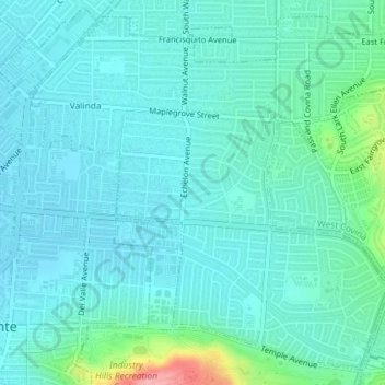
Name: Valinda topographic map, elevation, terrain.
Location: Valinda, Los Angeles County, California, United States (34.02468 -117.94890 34.05223 -117.91269)
Average elevation: 121 m
Minimum elevation: 100 m
Maximum elevation: 224 m
Make a donation
Other topographic maps
Click on a map to view its topography, its elevation and its terrain.
Hollywood Hills
United States > California > Los Angeles County > Los Angeles
Average elevation: 242 m
Make a donation
Pacific Palisades
United States > California > Los Angeles County > Los Angeles
Pacific Palisades was formally founded in 1921 by a Methodist organization, and in the years that followed became a refuge for Jewish artists and intellectuals fleeing the Holocaust. The Palisades would later be sought after by celebrities and other high-profile individuals seeking privacy. It is known for its…
Average elevation: 196 m
Make a donation
Calabasas Highlands
United States > California > Los Angeles County > Calabasas
Average elevation: 404 m
Make a donation
Make a donation
Los Angeles City Council District 7
United States > California > Los Angeles County > Los Angeles
Average elevation: 512 m
West Hills Neighborhood Council District
United States > California > Los Angeles County > Los Angeles
Average elevation: 319 m
Make a donation
Angeles National Forest
United States > California > Los Angeles County
The Angeles National Forest manages the habitats, flora and fauna ecosystems, and watersheds. Some of the rivers with watersheds within its boundaries provide valuable non-groundwater recharge water for Southern California. The existing protected and restored native vegetation absorb and slow surface runoff of…
Average elevation: 782 m
Los Angeles City Council District 5
United States > California > Los Angeles County > Los Angeles
Average elevation: 131 m
Make a donation
Make a donation
Santa Clarita
United States > California > Los Angeles County > Santa Clarita
Average elevation: 525 m
Make a donation
Mount Lukens
United States > California > Los Angeles County > Los Angeles
It is in the Sunland-Tujunga community within the northeast corner of the city of Los Angeles, above the Crescenta Valley. The summit, at 5,075 feet (1,547 m) in elevation, is the highest point within the city limits. The summit's elevation makes Los Angeles the city with the largest difference between high…
Average elevation: 1,176 m
San Pedro Hill
United States > California > Los Angeles County > Rancho Palos Verdes
Average elevation: 285 m
Make a donation
Topanga State Park
United States > California > Los Angeles County > Los Angeles
Average elevation: 333 m
Hollywood Riviera
United States > California > Los Angeles County > Torrance > Hollywood Riviera
Average elevation: 50 m
Make a donation
Runyon Canyon Park
United States > California > Los Angeles County > Los Angeles
Average elevation: 235 m
Make a donation
Val Verde
United States > California > Los Angeles County
Val Verde is located in the San Martinez Chiquito Canyon in the southeastern foothills of the Topatopa Mountains at an elevation ranging from 1,250–1,400 feet (380–430 m). The canyon contains a creek with runs intermittently through the community. It is about 50 miles (80 km) northwest of the county seat…
Average elevation: 440 m
Make a donation
Make a donation
Make a donation
Los Angeles City Council District 6
United States > California > Los Angeles County > Los Angeles
Average elevation: 252 m
Arleta Neighborhood Council District
United States > California > Los Angeles County > Los Angeles
Average elevation: 274 m
Make a donation
Woodside Village
United States > California > Los Angeles County > West Covina
Average elevation: 176 m
Mission Junction
United States > California > Los Angeles County > Los Angeles
Average elevation: 103 m
Topanga Oaks
United States > California > Los Angeles County > Topanga > Topanga Oaks
Average elevation: 371 m
Make a donation
Make a donation
Thenard
United States > California > Los Angeles County > Los Angeles > Thenard
Average elevation: 8 m
Adams Square
United States > California > Los Angeles County > Glendale > Adams Square
Average elevation: 168 m
Make a donation
Make a donation
Altacanyada
United States > California > Los Angeles County > La Cañada Flintridge
Average elevation: 584 m
Whittier Narrows
United States > California > Los Angeles County > South El Monte
Average elevation: 75 m
Make a donation
Make a donation