
Thank you for supporting this site ❤️
Make a donation
Make a donation
Wilson Creek topographic map
Click on the map to display elevation.
Thank you for supporting this site ❤️
Make a donation
Make a donation
About this map
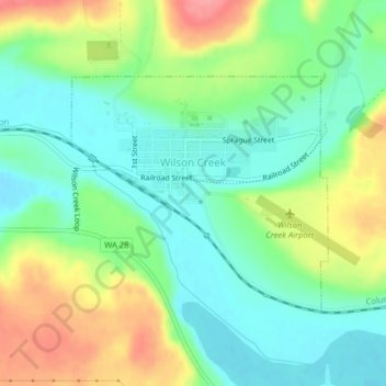
Name: Wilson Creek topographic map, elevation, terrain.
Location: Wilson Creek, Grant County, Washington, United States (47.41278 -119.13347 47.42920 -119.10688)
Average elevation: 415 m
Minimum elevation: 381 m
Maximum elevation: 472 m
Thank you for supporting this site ❤️
Make a donation
Make a donation
Other topographic maps
Click on a map to view its topography, its elevation and its terrain.
Thank you for supporting this site ❤️
Make a donation
Make a donation
Moses Lake
United States > Washington > Grant County > Moses Lake > Moses Lake
Average elevation: 342 m