
Thank you for supporting this site ❤️
Make a donation
Make a donation
Vesta topographic map
Click on the map to display elevation.
Thank you for supporting this site ❤️
Make a donation
Make a donation
About this map
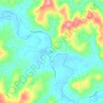
Name: Vesta topographic map, elevation, terrain.
Location: Vesta, Grays Harbor County, Washington, United States (46.81315 -123.60877 46.85315 -123.56877)
Average elevation: 86 m
Minimum elevation: 35 m
Maximum elevation: 208 m
Thank you for supporting this site ❤️
Make a donation
Make a donation
Other topographic maps
Click on a map to view its topography, its elevation and its terrain.
Chehalis Village
United States > Washington > Grays Harbor County > Chehalis Village
Average elevation: 42 m
Thank you for supporting this site ❤️
Make a donation
Make a donation
Thank you for supporting this site ❤️
Make a donation
Make a donation
Thank you for supporting this site ❤️
Make a donation
Make a donation
Thank you for supporting this site ❤️
Make a donation
Make a donation
North Fork West Branch Wynoochee River
United States > Washington > Grays Harbor County
Average elevation: 837 m
Pacific Beach
United States > Washington > Grays Harbor County > Pacific Beach
Average elevation: 19 m