
Liangjiang topographic map
Click on the map to display elevation.
About this map
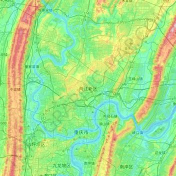
Name: Liangjiang topographic map, elevation, terrain.
Location: Liangjiang, Liangjiang New Area, Chongqing, 401122, China (29.48523 106.40248 29.80523 106.72248)
Average elevation: 321 m
Minimum elevation: 148 m
Maximum elevation: 807 m
Other topographic maps
Click on a map to view its topography, its elevation and its terrain.
Pengshui Miao and Tujia Autonomous County
China > Chongqing > Pengshui Miao and Tujia Autonomous County
Average elevation: 926 m
Wanzhou
Wanzhou spans 30°24′−31°14′ N latitude and 107°55′−108°53′ E longitude, and is situated at the eastern edge of the Sichuan Basin. It reaches a maximal north–south extent of 67.25 km (41.79 mi) and east–west width of 97.25 km (60.43 mi), covering an area of 3,214 km2 (1,241 sq mi).…
Average elevation: 651 m
Jiangjin District
Jiangjin lies within central China at 105°49′—106°38′of longitude and 28°28′—29°28′of north latitude. The landscape and topography of Jiangjin slopes from high elevations in the south and low in the north. Luohuangzhongba stands at the lowest elevation (178.5 m). The highest site, Wugongba in…
Average elevation: 521 m
Banan District
Banan, situated in the southern part of the Sichuan Basin, has a diversity of terrains including mountains, hills, wetlands and flood beds. The lowest point of the district is on its northern border with Nan'an District, at an altitude of 154 meters. The highest point is the top of Fangdou Mountain in the…
Average elevation: 445 m