
Thank you for supporting this site ❤️
Make a donation
Make a donation
Blue Canyon topographic map
Click on the map to display elevation.
Thank you for supporting this site ❤️
Make a donation
Make a donation
Blue Canyon
Blue Canyon (also, Blue Cañon) is an unincorporated community in Placer County, California. Blue Canyon is located 4 miles (6.4 km) southwest of Emigrant Gap. It lies at an elevation of 4695 feet (1431 m).
Thank you for supporting this site ❤️
Make a donation
Make a donation
About this map
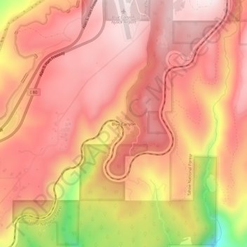
Name: Blue Canyon topographic map, elevation, terrain.
Average elevation: 1,452 m
Minimum elevation: 1,071 m
Maximum elevation: 1,612 m
Thank you for supporting this site ❤️
Make a donation
Make a donation
Other topographic maps
Click on a map to view its topography, its elevation and its terrain.
North Tahoe Regional Park
United States > California > Placer County > Tahoe Vista
Average elevation: 2,007 m
Thank you for supporting this site ❤️
Make a donation
Make a donation
Thank you for supporting this site ❤️
Make a donation
Make a donation