
Thank you for supporting this site ❤️
Make a donation
Make a donation
Twee Riviere topographic map
Click on the map to display elevation.
Thank you for supporting this site ❤️
Make a donation
Make a donation
About this map
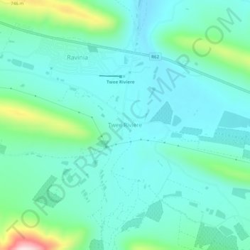
Name: Twee Riviere topographic map, elevation, terrain.
Average elevation: 575 m
Minimum elevation: 501 m
Maximum elevation: 876 m
Thank you for supporting this site ❤️
Make a donation
Make a donation
Other topographic maps
Click on a map to view its topography, its elevation and its terrain.
Waboomsrivier
South Africa > Eastern Cape > Sarah Baartman District Municipality > Kou-Kamma Local Municipality > Joubertina
Average elevation: 559 m