
Valère topographic map
Interactive map
Click on the map to display elevation.
About this map
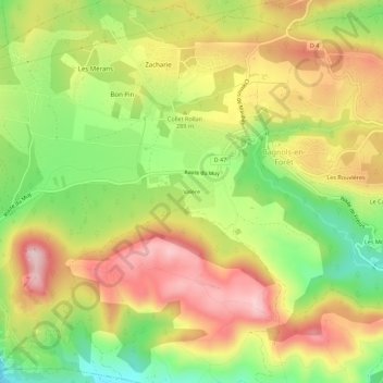
Name: Valère topographic map, elevation, terrain.
Average elevation: 272 m
Minimum elevation: 115 m
Maximum elevation: 423 m
Other topographic maps
Click on a map to view its topography, its elevation and its terrain.
Tubiere
France > Provence-Alpes-Côte d'Azur > Var > Bagnols-en-Forêt > Tubiere
Tubiere, Bagnols-en-Forêt, Draguignan, Var, Provence-Alpes-Côte d'Azur, France métropolitaine, 83600, France
Average elevation: 254 m
Rayol
France > Provence-Alpes-Côte d'Azur > Var > Bagnols-en-Forêt > Rayol
Rayol, Bagnols-en-Forêt, Draguignan, Var, Provence-Alpes-Côte d'Azur, France métropolitaine, 83600, France
Average elevation: 271 m
Saint-Anne
France > Provence-Alpes-Côte d'Azur > Var > Bagnols-en-Forêt
Saint-Anne, Bagnols-en-Forêt, Draguignan, Var, Provence-Alpes-Côte d'Azur, France métropolitaine, 83600, France
Average elevation: 272 m