
Thank you for supporting this site ❤️
Make a donation
Make a donation
Nairobi topographic map
Click on the map to display elevation.
Thank you for supporting this site ❤️
Make a donation
Make a donation
Nairobi
Nairobi was founded in 1899 as a rail depot on the Uganda - Kenya Railway. It was favoured by the authorities as an ideal resting place due to its high elevation, temperate climate, and adequate water supply. The town quickly grew to replace Mombasa as the capital of Kenya in 1907.
Thank you for supporting this site ❤️
Make a donation
Make a donation
About this map
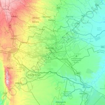
Name: Nairobi topographic map, elevation, terrain.
Location: Nairobi, Starehe, Nairobi County, Nairobi, Kenya (-1.44488 36.66470 -1.16067 37.10487)
Average elevation: 1,729 m
Minimum elevation: 1,456 m
Maximum elevation: 2,442 m
Thank you for supporting this site ❤️
Make a donation
Make a donation