
Make a donation
Pauh Duo topographic map
Click on the map to display elevation.
Make a donation
About this map
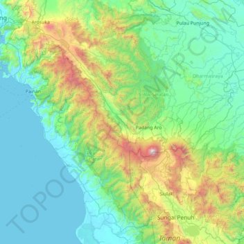
Name: Pauh Duo topographic map, elevation, terrain.
Location: Pauh Duo, West Sumatra, Sumatra, Indonesia (-2.22640 100.38808 -0.82640 101.78808)
Average elevation: 590 m
Minimum elevation: 0 m
Maximum elevation: 3,715 m
Make a donation
Other topographic maps
Click on a map to view its topography, its elevation and its terrain.
Make a donation
Batang Air Bayang Gadang
Indonesia > West Sumatra > Pesisir Selatan > Pancuang Taba
Average elevation: 1,331 m
Sawahlunto
Indonesia > West Sumatra > Kupitan
Sawahlunto has a maximum elevation of about 650m above sea level. The landscape is primarily made up of steep hills which act as a hindrance to the development of the town. The old town centre spanned 5.8 km2. Relatively flat lands can be found in the Kecamatan Talawi district. The area that runs from north to…
Average elevation: 372 m
Make a donation
Make a donation
Make a donation
Make a donation
Make a donation
Make a donation
Make a donation
Make a donation