
Thank you for supporting this site ❤️
Make a donation
Make a donation
Trenton topographic map
Click on the map to display elevation.
Thank you for supporting this site ❤️
Make a donation
Make a donation
About this map
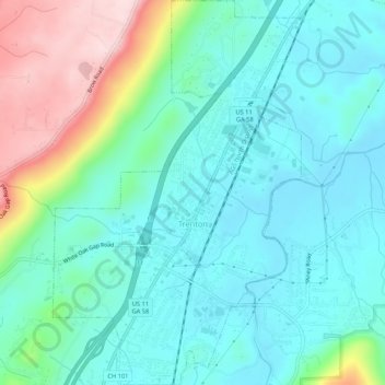
Name: Trenton topographic map, elevation, terrain.
Location: Trenton, Dade County, Georgia, United States (34.85374 -85.52850 34.89734 -85.49415)
Average elevation: 280 m
Minimum elevation: 205 m
Maximum elevation: 508 m
Thank you for supporting this site ❤️
Make a donation
Make a donation
Other topographic maps
Click on a map to view its topography, its elevation and its terrain.
Thank you for supporting this site ❤️
Make a donation
Make a donation
Thank you for supporting this site ❤️
Make a donation
Make a donation