
Crown Point topographic map
Interactive map
Click on the map to display elevation.
About this map
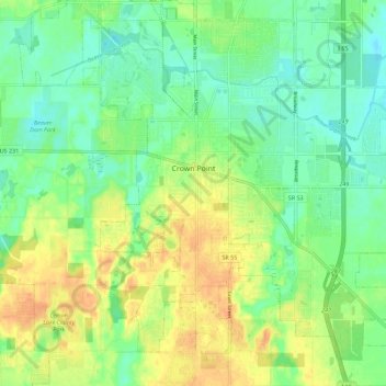
Name: Crown Point topographic map, elevation, terrain.
Location: Crown Point, Lake County, Indiana, 46307, United States (41.36921 -87.39758 41.45373 -87.29672)
Average elevation: 220 m
Minimum elevation: 204 m
Maximum elevation: 240 m
Other topographic maps
Click on a map to view its topography, its elevation and its terrain.
Center Township
United States > Indiana > Lake County
Center Township, Lake County, Indiana, 46307, United States
Average elevation: 220 m
Three Rivers Park Lake
United States > Indiana > Lake County > Lake Station
Three Rivers Park Lake, Lake Station, Hobart Township, Lake County, Indiana, United States
Average elevation: 186 m
Miller
United States > Indiana > Lake County > Gary
Miller, Miller Beach, Gary, Calumet Township, Lake County, Indiana, 46403, United States
Average elevation: 186 m
Lowell
United States > Indiana > Lake County
Lowell, Lake County, Indiana, 46356, United States
Average elevation: 214 m
Illinoi
United States > Indiana > Lake County
Illinoi, Lake County, Indiana, United States
Average elevation: 192 m
Grand Calumet River
United States > Indiana > Lake County > Gary
Grand Calumet River, Gary, Thornton Township, Lake County, Indiana, United States
Average elevation: 180 m
Merrillville
United States > Indiana > Lake County
Merrillville, Ross Township, Lake County, Indiana, 46410, United States
Average elevation: 204 m
Cedar Lake
United States > Indiana > Lake County
Cedar Lake, Hanover Township, Lake County, Indiana, 46303, United States
Average elevation: 223 m
Griffith
United States > Indiana > Lake County
Griffith, Lake County, Indiana, 46319, United States
Average elevation: 190 m
Schererville
United States > Indiana > Lake County
Schererville, Lake County, Indiana, 46375, United States
Average elevation: 203 m
New Chicago
United States > Indiana > Lake County
New Chicago, Lake County, Indiana, United States
Average elevation: 192 m
Lake Station
United States > Indiana > Lake County
Lake Station, Hobart Township, Lake County, Indiana, 46405, United States
Average elevation: 189 m
Highland
United States > Indiana > Lake County
Highland, Lake County, Indiana, 46322, United States
Average elevation: 188 m
Winfield
United States > Indiana > Lake County
Winfield, Lake County, Indiana, United States
Average elevation: 216 m
St. John
United States > Indiana > Lake County
St. John, Lake County, Indiana, 46373, United States
Average elevation: 213 m
Gary
United States > Indiana > Lake County
Gary, Calumet Township, Lake County, Indiana, United States
Average elevation: 185 m
Munster
United States > Indiana > Lake County
Munster, Lake County, Indiana, 46321, United States
Average elevation: 187 m
Hammond
United States > Indiana > Lake County > Hammond > Hammond
Hammond, Lake County, Indiana, 46324, United States
Average elevation: 184 m
Gary
United States > Indiana > Lake County > Gary
Gary, Lake County, Indiana, 46402, United States
Average elevation: 187 m
Dyer
United States > Indiana > Lake County
Dyer, Lake County, Indiana, 46311, United States
Average elevation: 196 m
East Chicago
United States > Indiana > Lake County
East Chicago, Lake County, Indiana, 46312, United States
Average elevation: 179 m
Hammond
United States > Indiana > Lake County
Hammond, Lake County, Indiana, United States
Average elevation: 180 m
Hobart
United States > Indiana > Lake County
Hobart, Hobart Township, Lake County, Indiana, 46342, United States
Average elevation: 197 m