
Sparks topographic map
Interactive map
Click on the map to display elevation.
About this map
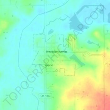
Name: Sparks topographic map, elevation, terrain.
Location: Sparks, Lincoln County, Oklahoma, 74869, United States (35.60597 -96.82596 35.61553 -96.81316)
Average elevation: 256 m
Minimum elevation: 240 m
Maximum elevation: 293 m
Other topographic maps
Click on a map to view its topography, its elevation and its terrain.
Prague
United States > Oklahoma > Lincoln County
Prague, Lincoln County, Oklahoma, United States
Average elevation: 304 m
Stroud
United States > Oklahoma > Lincoln County
Stroud, Lincoln County, Oklahoma, 74079, United States
Average elevation: 272 m
Agra
United States > Oklahoma > Lincoln County
Agra, Lincoln County, Oklahoma, United States
Average elevation: 309 m
Wellston
United States > Oklahoma > Lincoln County
Wellston, Lincoln County, Oklahoma, 74881, United States
Average elevation: 273 m
Chandler
United States > Oklahoma > Lincoln County
Chandler, Lincoln County, Oklahoma, 74834, United States
Average elevation: 280 m
Chandler
United States > Oklahoma > Lincoln County > Chandler > Chandler
Chandler, Lincoln County, Oklahoma, 74834, United States
Average elevation: 279 m
Meeker
United States > Oklahoma > Lincoln County > Meeker
Meeker, Lincoln County, Oklahoma, United States
Average elevation: 292 m
Chandler Lake
United States > Oklahoma > Lincoln County > Chandler
Chandler Lake, Chandler, Lincoln County, Oklahoma, United States
Average elevation: 283 m