
Thank you for supporting this site ❤️
Make a donation
Make a donation
Dumfries topographic map
Click on the map to display elevation.
Thank you for supporting this site ❤️
Make a donation
Make a donation
About this map
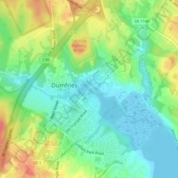
Name: Dumfries topographic map, elevation, terrain.
Location: Dumfries, Prince William County, Virginia, United States (38.55494 -77.33922 38.57893 -77.30120)
Average elevation: 27 m
Minimum elevation: -7 m
Maximum elevation: 73 m
Thank you for supporting this site ❤️
Make a donation
Make a donation
Other topographic maps
Click on a map to view its topography, its elevation and its terrain.
Prince William Forest Park
United States > Virginia > Prince William County > Triangle
Average elevation: 81 m
Thank you for supporting this site ❤️
Make a donation
Make a donation