
Make a donation
Lake Wheeler topographic map
Click on the map to display elevation.
Make a donation
About this map
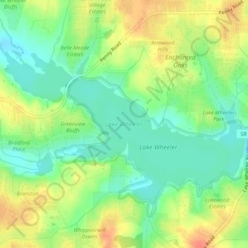
Name: Lake Wheeler topographic map, elevation, terrain.
Location: Lake Wheeler, Wake County, North Carolina, United States (35.68503 -78.73328 35.70582 -78.69402)
Average elevation: 104 m
Minimum elevation: 82 m
Maximum elevation: 131 m
Make a donation
Other topographic maps
Click on a map to view its topography, its elevation and its terrain.
Make a donation
Make a donation
Pickwick Village
United States > North Carolina > Wake County > Raleigh > Pickwick Village
Average elevation: 117 m
Fuquay-Varina
United States > North Carolina > Wake County > Fuquay-Varina
Fuquay-Varina is located in the northeast central region of North Carolina, where the North American Piedmont and Atlantic Coastal Plain regions meet. This area is known as the "Fall Line" because it marks the elevation inland at which waterfalls begin to appear in creeks and rivers. Its central Piedmont…
Average elevation: 120 m
Make a donation