
Thank you for supporting this site ❤️
Make a donation
Make a donation
Otsego topographic map
Click on the map to display elevation.
Thank you for supporting this site ❤️
Make a donation
Make a donation
About this map
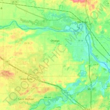
Name: Otsego topographic map, elevation, terrain.
Location: Otsego, Wright County, Minnesota, United States (45.22237 -93.70481 45.30506 -93.51490)
Average elevation: 281 m
Minimum elevation: 255 m
Maximum elevation: 322 m
Thank you for supporting this site ❤️
Make a donation
Make a donation
Other topographic maps
Click on a map to view its topography, its elevation and its terrain.
South Haven
United States > Minnesota > Wright County > South Haven > South Haven
Average elevation: 331 m
Maple Lake
United States > Minnesota > Wright County > Maple Lake > Maple Lake
Average elevation: 314 m
Thank you for supporting this site ❤️
Make a donation
Make a donation