
Thank you for supporting this site ❤️
Make a donation
Make a donation
Weißenfels topographic map
Click on the map to display elevation.
Thank you for supporting this site ❤️
Make a donation
Make a donation
About this map
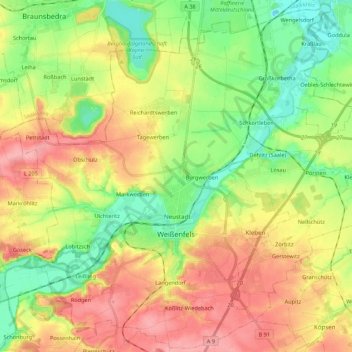
Name: Weißenfels topographic map, elevation, terrain.
Location: Weißenfels, Burgenlandkreis, Saxony-Anhalt, Germany (51.15583 11.85860 51.28877 12.07526)
Average elevation: 139 m
Minimum elevation: 85 m
Maximum elevation: 205 m
Thank you for supporting this site ❤️
Make a donation
Make a donation
Other topographic maps
Click on a map to view its topography, its elevation and its terrain.
Tromsdorf
Germany > Saxony-Anhalt > Burgenlandkreis > Eckartsberga > Tromsdorf
Average elevation: 195 m