Geolocate

新政镇 topographic map

Interactive map

Click on the map to display elevation.

About this map

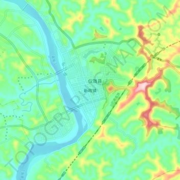
Name: 新政镇 topographic map, elevation, terrain.

Location: 新政镇, 仪陇县, 南充市, 四川省, 中国 (31.22796 106.25670 31.30796 106.33670)

Average elevation: 377 m

Minimum elevation: 300 m

Maximum elevation: 585 m

Other topographic maps

Click on a map to view its topography, its elevation and its terrain.

马鞍镇

中国 > 四川省 > 仪陇县

马鞍镇, 仪陇县, 南充市, 四川省, 中国

Average elevation: 468 m

土门镇

中国 > 四川省 > 仪陇县

土门镇, 仪陇县, 南充市, 四川省, 中国

Average elevation: 424 m

仪陇县

中国 > 四川省 > 仪陇县

仪陇县, 南充市, 四川省, 中国

Average elevation: 386 m