
Thank you for supporting this site ❤️
Make a donation
Make a donation
Roche Béranger topographic map
Click on the map to display elevation.
Thank you for supporting this site ❤️
Make a donation
Make a donation
Roche Béranger
The road to the ski station starts at Uriage-les-Bains from where the climb is 19 km (12 mi) long, gaining 1,235 m (4,052 ft) in elevation, at an average gradient of 6.5%. There are several sections in excess off 11% in the early stages of the climb. For the Tour de France, the summit is at an elevation of 1,730 m (5,680 ft).
Thank you for supporting this site ❤️
Make a donation
Make a donation
About this map
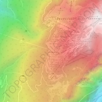
Name: Roche Béranger topographic map, elevation, terrain.
Average elevation: 1,561 m
Minimum elevation: 539 m
Maximum elevation: 2,250 m
Thank you for supporting this site ❤️
Make a donation
Make a donation