
五峰公园 topographic map
Interactive map
Click on the map to display elevation.
About this map
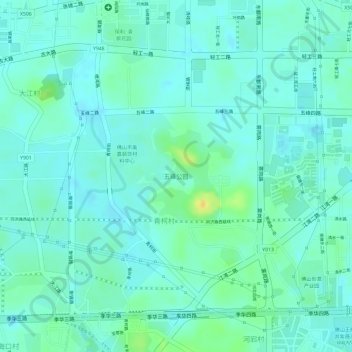
Name: 五峰公园 topographic map, elevation, terrain.
Location: 五峰公园, 张槎街道, 禅城区, 佛山市, 广东省, 中国 (23.02097 113.07842 23.02847 113.08595)
Average elevation: 9 m
Minimum elevation: 1 m
Maximum elevation: 31 m
Other topographic maps
Click on a map to view its topography, its elevation and its terrain.
禅城区
禅城区位于珠江三角洲腹地,广州市西南,佛山市中部,东、西、北面与南海区接壤,东南、南面与顺德区接壤,南北长15公里,东西宽19公里,面积154.09平方公里。禅城区为平坦的冲积平原,绝大部分海拔为1.3到4.6米,零星小山丘的海拔在1750米以下。地貌以堆积地系列为主,属三角洲平原,组成物质为亚砂土和淤泥层,属珠江三角洲沉积的顶积层。地表大部分被松散沉积物所覆盖,厚约15到25米。地质属第四纪地层,以粘土为主,其他为粒径不等的沙层。矿产资源主要为非金属矿,其中石膏石分布广,质量好,储量丰富,属于与断陷盆地有关的湖相蒸发膏盐矿床。
Average elevation: 8 m