
Make a donation
Colchuck Lake topographic map
Click on the map to display elevation.
Make a donation
Colchuck Lake
Colchuck Lake has an area of approximately 87.8 acres (0.355 km2) and a maximum surface elevation of 5,570 feet above sea level, depending on the fluctuation of the depth of the lake. The lake has a tributary basin of 941 acres (3.81 km2) acres, and an average storage capacity estimated at 1,570 acre-feet.
Make a donation
About this map
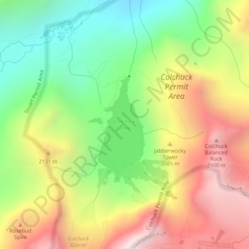
Name: Colchuck Lake topographic map, elevation, terrain.
Location: Colchuck Lake, Chelan County, Washington, United States (47.48792 -120.83767 47.49839 -120.82992)
Average elevation: 1,886 m
Minimum elevation: 1,262 m
Maximum elevation: 2,626 m
Make a donation
Other topographic maps
Click on a map to view its topography, its elevation and its terrain.
Liberty Bell Mountain
United States > Washington > Chelan County
It is a well-known peak in Washington, although it lacks high prominence and elevation. It is well known for having high-quality alpine climbing, with a short approach since the completion of The Washington Pass Highway. A mixture of high-quality granite and difficult rock has made it a very popular weekend…
Average elevation: 1,834 m
Make a donation
Make a donation
Make a donation
Leavenworth
United States > Washington > Chelan County > Leavenworth > Leavenworth
Average elevation: 604 m
Make a donation
Make a donation