
Thank you for supporting this site ❤️
Make a donation
Make a donation
Lemoyne topographic map
Click on the map to display elevation.
Thank you for supporting this site ❤️
Make a donation
Make a donation
About this map
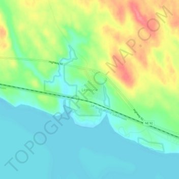
Name: Lemoyne topographic map, elevation, terrain.
Location: Lemoyne, Keith County, Nebraska, 69146, United States (41.25761 -101.83263 41.29761 -101.79263)
Average elevation: 1,017 m
Minimum elevation: 989 m
Maximum elevation: 1,070 m
Thank you for supporting this site ❤️
Make a donation
Make a donation
Other topographic maps
Click on a map to view its topography, its elevation and its terrain.