
Thank you for supporting this site ❤️
Make a donation
Make a donation
The Villages topographic map
Click on the map to display elevation.
Thank you for supporting this site ❤️
Make a donation
Make a donation
About this map
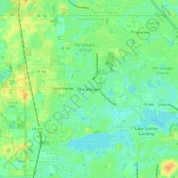
Name: The Villages topographic map, elevation, terrain.
Location: The Villages, Sumter County, Florida, 32162, United States (28.88700 -82.04418 28.96700 -81.96418)
Average elevation: 24 m
Minimum elevation: 12 m
Maximum elevation: 46 m
Thank you for supporting this site ❤️
Make a donation
Make a donation
Other topographic maps
Click on a map to view its topography, its elevation and its terrain.