
Thank you for supporting this site ❤️
Make a donation
Make a donation
LaPorte County topographic map
Click on the map to display elevation.
Thank you for supporting this site ❤️
Make a donation
Make a donation
About this map
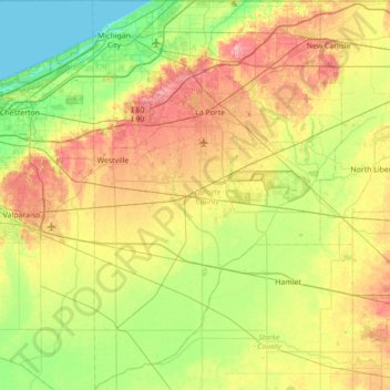
Name: LaPorte County topographic map, elevation, terrain.
Location: LaPorte County, Indiana, United States (41.23680 -86.93416 41.76104 -86.48617)
Average elevation: 219 m
Minimum elevation: 175 m
Maximum elevation: 290 m
Thank you for supporting this site ❤️
Make a donation
Make a donation
Other topographic maps
Click on a map to view its topography, its elevation and its terrain.
Thank you for supporting this site ❤️
Make a donation
Make a donation
Thank you for supporting this site ❤️
Make a donation
Make a donation
Lake Station
United States > Indiana > Lake County > Lake Station > Lake Station
Average elevation: 189 m