
Thank you for supporting this site ❤️
Make a donation
Make a donation
Guatemala City topographic map
Click on the map to display elevation.
Thank you for supporting this site ❤️
Make a donation
Make a donation
Guatemala City
Despite its location in the tropics, Guatemala City has a tropical savanna climate (Köppen Aw) bordering humid subtropical climate (Cwa), due to its relatively high altitude which moderate the average temperatures. Guatemala City is generally very warm, almost springlike, throughout the course of the year.
Thank you for supporting this site ❤️
Make a donation
Make a donation
About this map
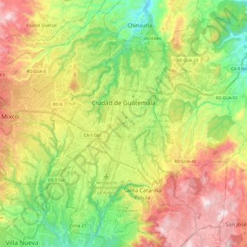
Name: Guatemala City topographic map, elevation, terrain.
Location: Guatemala City, Guatemala Department, Guatemala (14.53641 -90.58709 14.71379 -90.38541)
Average elevation: 1,531 m
Minimum elevation: 1,164 m
Maximum elevation: 2,016 m
Thank you for supporting this site ❤️
Make a donation
Make a donation