
Crystal topographic map
Click on the map to display elevation.
Crystal
The elevation of Crystal is centered at 8,950 ft (2,728 m), however the area in and around crystal ranges from 8,500 ft (2,590.8 m) to peaks of 13,500 ft (4,114.8 m). The land is well drained, and the rock types, such as limestone, create very steep slopes, common in the Rocky Mountains. The area is described as having classically alpine terrain in characteristics, and the sources of the areas streams are mainly glacial cirques. Barren parts of the mountains that are at elevations, low enough to support vegetation growth, are primarily unable to support much vegetation, due to the steep slopes and the large accumulation of shale rocks.
About this map
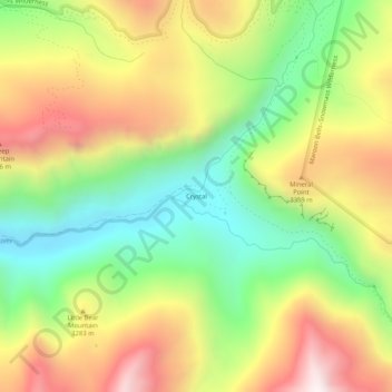
Name: Crystal topographic map, elevation, terrain.
Location: Crystal, Gunnison County, Colorado, United States (39.03916 -107.12116 39.07916 -107.08116)
Average elevation: 3,146 m
Minimum elevation: 2,672 m
Maximum elevation: 3,712 m
Other topographic maps
Click on a map to view its topography, its elevation and its terrain.
Crested Butte
United States > Colorado > Gunnison County
Crested Butte is located in north-central Gunnison County on the west side of the valley of the Slate River, along Coal Creek. Colorado State Highway 135 runs south from Crested Butte 27 miles (43 km) to Gunnison, the county seat. According to the United States Census Bureau, the town of Crested Butte has a…
Average elevation: 2,798 m
Crested Butte
United States > Colorado > Gunnison County
At the 2020 United States Census, the town had a total area of 535 acres (2.166 km2), all of it land. Crested Butte lies at an elevation of 8,885 feet (2,708 m) above sea level.
Average elevation: 2,798 m
Crested Butte
United States > Colorado > Gunnison County
At the 2020 United States census, the town had a total area of 535 acres (2.166 km2), all of it land. Crested Butte lies at an elevation of 8,885 feet (2,708 m) above sea level.
Average elevation: 2,798 m