
La Gachet topographic map
Interactive map
Click on the map to display elevation.
About this map
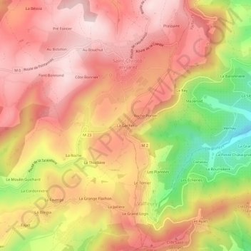
Name: La Gachet topographic map, elevation, terrain.
Average elevation: 716 m
Minimum elevation: 440 m
Maximum elevation: 878 m
Other topographic maps
Click on a map to view its topography, its elevation and its terrain.
Au Bouchut
France > Auvergne-Rhône-Alpes > Loire > Saint-Christo-en-Jarez
Au Bouchut, Saint-Christo-en-Jarez, Saint-Étienne, Loire, Auvergne-Rhône-Alpes, France métropolitaine, 42320, France
Average elevation: 761 m
Prassaint
France > Auvergne-Rhône-Alpes > Loire > Saint-Christo-en-Jarez
Prassaint, Saint-Christo-en-Jarez, Saint-Étienne, Loire, Auvergne-Rhône-Alpes, France métropolitaine, 42320, France
Average elevation: 714 m
Cochollon
France > Auvergne-Rhône-Alpes > Loire > Saint-Christo-en-Jarez
Cochollon, Saint-Christo-en-Jarez, Saint-Étienne, Loire, Auvergne-Rhône-Alpes, France métropolitaine, 42320, France
Average elevation: 694 m