
Thank you for supporting this site ❤️
Make a donation
Make a donation
Office Hall topographic map
Click on the map to display elevation.
Thank you for supporting this site ❤️
Make a donation
Make a donation
About this map
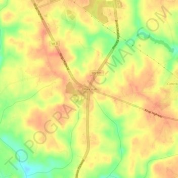
Name: Office Hall topographic map, elevation, terrain.
Location: Office Hall, King George County, Virginia, United States (38.21902 -77.17025 38.25902 -77.13025)
Average elevation: 47 m
Minimum elevation: 15 m
Maximum elevation: 64 m
Thank you for supporting this site ❤️
Make a donation
Make a donation
Other topographic maps
Click on a map to view its topography, its elevation and its terrain.