
Thank you for supporting this site ❤️
Make a donation
Make a donation
Hawaii topographic map
Click on the map to display elevation.
Thank you for supporting this site ❤️
Make a donation
Make a donation
About this map
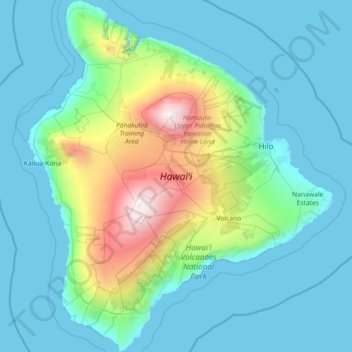
Name: Hawaii topographic map, elevation, terrain.
Location: Hawaii, United States (18.91069 -156.06188 20.26850 -154.80670)
Average elevation: 547 m
Minimum elevation: 0 m
Maximum elevation: 4,187 m
Thank you for supporting this site ❤️
Make a donation
Make a donation
Other topographic maps
Click on a map to view its topography, its elevation and its terrain.