
Thank you for supporting this site ❤️
Make a donation
Make a donation
Batu Hampar topographic map
Click on the map to display elevation.
Thank you for supporting this site ❤️
Make a donation
Make a donation
About this map
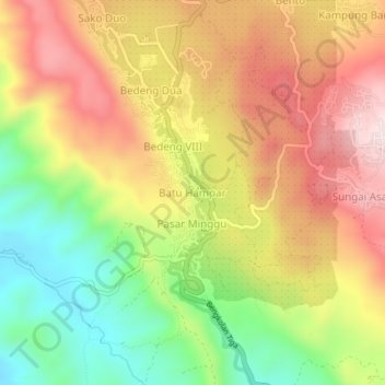
Name: Batu Hampar topographic map, elevation, terrain.
Location: Batu Hampar, Kerinci, Jambi, Sumatra, 18282, Indonesia (-1.85126 101.23955 -1.81126 101.27955)
Average elevation: 1,404 m
Minimum elevation: 1,177 m
Maximum elevation: 1,616 m
Thank you for supporting this site ❤️
Make a donation
Make a donation
Other topographic maps
Click on a map to view its topography, its elevation and its terrain.