
Thank you for supporting this site ❤️
Make a donation
Make a donation
Tulusrejo topographic map
Click on the map to display elevation.
Thank you for supporting this site ❤️
Make a donation
Make a donation
About this map
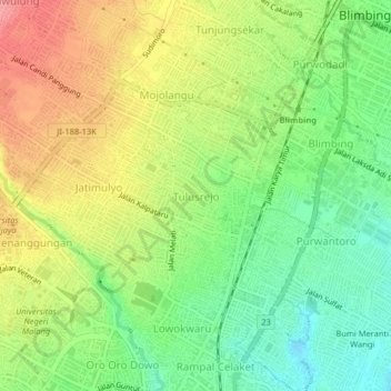
Name: Tulusrejo topographic map, elevation, terrain.
Average elevation: 473 m
Minimum elevation: 432 m
Maximum elevation: 521 m
Thank you for supporting this site ❤️
Make a donation
Make a donation
Other topographic maps
Click on a map to view its topography, its elevation and its terrain.
RW 11 Kelurahan Merjosari Kecamatan Lowokwaru Kota Malang
Indonesia > East Java > Kota Malang > Malang
Average elevation: 597 m
RW 06 Kel. Kotalama Kec. Kedung Kandang, Kota Malang
Indonesia > East Java > Kota Malang > Malang > Kotalama
Average elevation: 434 m