
Make a donation
Jishou topographic map
Click on the map to display elevation.
Make a donation
Jishou
Jishou lies east of the Wuling Mountain range. About 80% of the city's terrain is low hills or low mountains. The highest elevation is 964.5 meters, at Liantaifeng (莲台峰; 蓮台峰, near the town of Aizhai (矮寨) and the lowest point is 142 meters, near the town of Hexi (simplified Chinese: 河溪镇; traditional Chinese: 河溪鎮). The Dong River (峒河), a tributary of the Yuan River, runs west to east through the city.
Make a donation
About this map
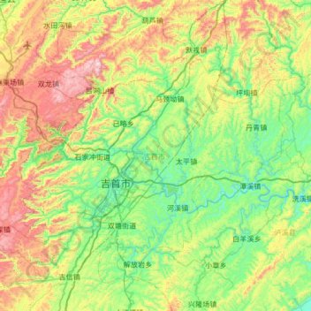
Name: Jishou topographic map, elevation, terrain.
Location: Jishou, Xiangxi, Hunan, China (28.14479 109.46750 28.47631 110.06018)
Average elevation: 447 m
Minimum elevation: 119 m
Maximum elevation: 1,170 m
Make a donation
Other topographic maps
Click on a map to view its topography, its elevation and its terrain.
Zhangjiajie Tianmen Mountain National Forest Park
China > Hunan > Yongding District
Average elevation: 781 m
Zhangjiajie Tianmen Mountain National Forest Park
China > Hunan > Yongding District
Average elevation: 781 m
Make a donation
Make a donation
Make a donation
Make a donation
Make a donation
Make a donation
Ningxiang
China > Hunan > Ningxiang > Yutan Subdistrict
The highest natural elevation in Ningxiang County is 1071m at Wazizhai (瓦子寨).
Average elevation: 83 m
Make a donation
Make a donation
Make a donation
Make a donation
Make a donation
Xiangxi
China > Hunan > Jishou City > Zhenxi Subdistrict
Xiangxi Tujia and Miao Autonomous Prefecture is located in a low-latitude zone and has a humid subtropical monsoon climate. It is characterized by the influence of the topography of the Wuling Mountains: the winter is relatively cold, the summer temperature is high and humid, the spring and summer are wet and…
Average elevation: 542 m
Make a donation