
Aiken County topographic map
Interactive map
Click on the map to display elevation.
About this map
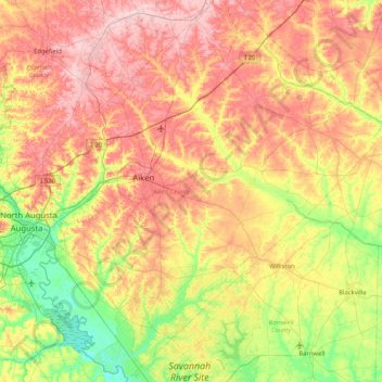
Name: Aiken County topographic map, elevation, terrain.
Location: Aiken County, South Carolina, United States (33.19796 -82.01253 33.87508 -81.18730)
Average elevation: 109 m
Minimum elevation: 22 m
Maximum elevation: 208 m
Other topographic maps
Click on a map to view its topography, its elevation and its terrain.
North Charleston
United States > South Carolina > North Charleston
North Charleston, Charleston County, South Carolina, United States
Average elevation: 5 m