
Krakow topographic map
Interactive map
Click on the map to display elevation.
About this map
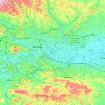
Name: Krakow topographic map, elevation, terrain.
Location: Krakow, Lesser Poland Voivodeship, Poland (49.96767 19.79224 50.12613 20.21735)
Average elevation: 258 m
Minimum elevation: 187 m
Maximum elevation: 457 m
Other topographic maps
Click on a map to view its topography, its elevation and its terrain.
Zakopane
Poland > Lesser Poland Voivodeship > Tatra County > Zakopane
Owing to its high elevation, Zakopane has a humid continental climate (Köppen climate classification: Dfb).
Average elevation: 974 m