
Thank you for supporting this site ❤️
Make a donation
Make a donation
Segovia topographic map
Click on the map to display elevation.
Thank you for supporting this site ❤️
Make a donation
Make a donation
Segovia
Segovia is one of nine provinces that make up the autonomous region of Castile and León. Burgos and Valladolid lie to the north, Ávila to the west, Madrid to the south, and Soria to the east. The altitude of the province varies from 750 metres (2,461 feet) in the extreme northwest to a maximum of 2,430 m (7,972 ft) at Peñalara peak in the Sierra de Guadarrama.
Thank you for supporting this site ❤️
Make a donation
Make a donation
About this map
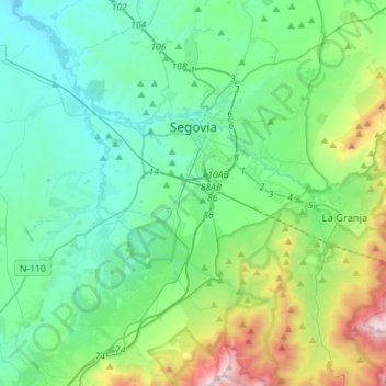
Name: Segovia topographic map, elevation, terrain.
Location: Segovia, Castile and León, Spain (40.83495 -4.33582 40.98799 -4.05245)
Average elevation: 1,142 m
Minimum elevation: 857 m
Maximum elevation: 2,188 m
Thank you for supporting this site ❤️
Make a donation
Make a donation