
Thank you for supporting this site ❤️
Make a donation
Make a donation
Burris Crossroads topographic map
Click on the map to display elevation.
Thank you for supporting this site ❤️
Make a donation
Make a donation
About this map
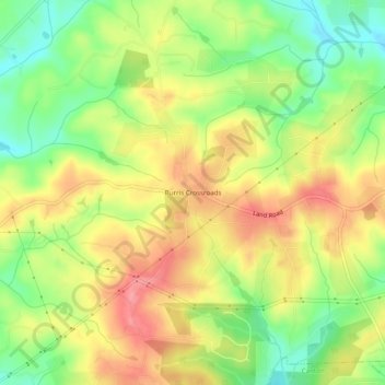
Name: Burris Crossroads topographic map, elevation, terrain.
Location: Burris Crossroads, Cherokee County, Georgia, United States (34.31009 -84.50743 34.35009 -84.46743)
Average elevation: 386 m
Minimum elevation: 338 m
Maximum elevation: 430 m
Thank you for supporting this site ❤️
Make a donation
Make a donation
Other topographic maps
Click on a map to view its topography, its elevation and its terrain.