
Thank you for supporting this site ❤️
Make a donation
Make a donation
Laxmangarh topographic map
Click on the map to display elevation.
Thank you for supporting this site ❤️
Make a donation
Make a donation
Laxmangarh
Laxmangarh is located at 27°49′21″N 75°01′31″E / 27.8225°N 75.025278°E / 27.8225; 75.025278. It has an average elevation of 222 metres (728 ft).
Thank you for supporting this site ❤️
Make a donation
Make a donation
About this map
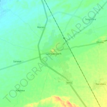
Name: Laxmangarh topographic map, elevation, terrain.
Average elevation: 360 m
Minimum elevation: 345 m
Maximum elevation: 391 m
Thank you for supporting this site ❤️
Make a donation
Make a donation