
Sedona topographic map
Interactive map
Click on the map to display elevation.
About this map
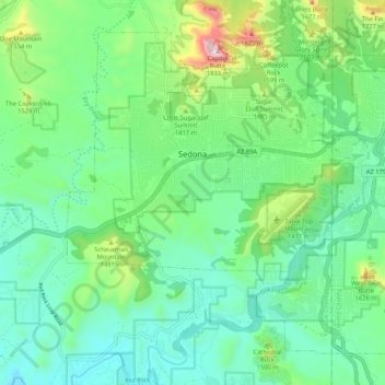
Name: Sedona topographic map, elevation, terrain.
Location: Sedona, Yavapai County, Arizona, 86336, United States (34.81807 -111.84819 34.89021 -111.74289)
Average elevation: 1,342 m
Minimum elevation: 1,141 m
Maximum elevation: 1,930 m
Sedona interior chaparral has many shrubs and small tree species of Quercus turbinella and Rhus ovata and a large population of Quercus palmeri. The Great Basin woodland has many small to medium trees of Pinus monophylla Var. fallax, Juniperus arizonica, Juniperus deppeana, Juniperus osteosperma, and Juniperus monosperma and a large population of Cupressus glabra. At higher elevations in Oak Creek Canyon Juniperus virginiana, Pinus edulis and other pines occur.