
Thank you for supporting this site ❤️
Make a donation
Make a donation
Versailles topographic map
Click on the map to display elevation.
Thank you for supporting this site ❤️
Make a donation
Make a donation
About this map
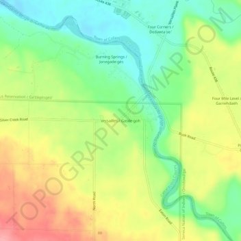
Name: Versailles topographic map, elevation, terrain.
Average elevation: 235 m
Minimum elevation: 188 m
Maximum elevation: 293 m
Thank you for supporting this site ❤️
Make a donation
Make a donation
Other topographic maps
Click on a map to view its topography, its elevation and its terrain.
Thank you for supporting this site ❤️
Make a donation
Make a donation
Weston Mills
United States > New York > Cattaraugus County > Town of Portville
Average elevation: 491 m
Thank you for supporting this site ❤️
Make a donation
Make a donation
Thank you for supporting this site ❤️
Make a donation
Make a donation
Saint Bonaventure
United States > New York > Cattaraugus County > Town of Allegany
Average elevation: 443 m
Thank you for supporting this site ❤️
Make a donation
Make a donation
Thank you for supporting this site ❤️
Make a donation
Make a donation
Thank you for supporting this site ❤️
Make a donation
Make a donation