Russell topographic map
Interactive map
Click on the map to display elevation.
About this map
![Russell topographic map, elevation, terrain](/pub/maps/node/3f18/fwvxk1h/thumbnail.jpg)
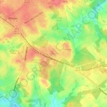
Name: Russell topographic map, elevation, terrain.
Location: Russell, Barrow County, Georgia, 30680, United States (33.95872 -83.72017 33.99872 -83.68017)
Average elevation: 279 m
Minimum elevation: 240 m
Maximum elevation: 308 m
Other topographic maps
Click on a map to view its topography, its elevation and its terrain.
![Fort Yargo State Park topographic map, elevation, terrain](/pub/maps/way/lcnh/s1dhgb3/icon.jpg)
Fort Yargo State Park
United States > Georgia > Barrow County > Winder
Fort Yargo State Park, Winder, Barrow County, Georgia, United States
Average elevation: 270 m
![Auburn topographic map, elevation, terrain](/pub/maps/relation/m8cz/m13mt/icon.jpg)
Auburn
United States > Georgia > Barrow County
Auburn, Barrow County, Georgia, 30011, United States
Average elevation: 300 m
![Statham topographic map, elevation, terrain](/pub/maps/relation/s9m2/426dn/icon.jpg)
Statham
United States > Georgia > Barrow County
Statham, Barrow County, Georgia, United States
Average elevation: 261 m
![Carl topographic map, elevation, terrain](/pub/maps/relation/15nx/81ngp/icon.jpg)
Carl
United States > Georgia > Barrow County
Carl, Barrow County, Georgia, United States
Average elevation: 317 m
![Bethlehem topographic map, elevation, terrain](/pub/maps/relation/hftj/d4bb3/icon.jpg)
Bethlehem
United States > Georgia > Barrow County
Bethlehem, Barrow County, Georgia, United States
Average elevation: 258 m
![Winder topographic map, elevation, terrain](/pub/maps/relation/cp57/lpw9m/icon.jpg)
Winder
United States > Georgia > Barrow County
Winder, Barrow County, Georgia, United States
Average elevation: 274 m