
Thank you for supporting this site ❤️
Make a donation
Make a donation
Ambohimena topographic map
Click on the map to display elevation.
Thank you for supporting this site ❤️
Make a donation
Make a donation
About this map
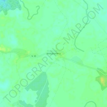
Name: Ambohimena topographic map, elevation, terrain.
Location: Ambohimena, Diana, Province d'Antsiranana, Madagascar (-13.63645 48.39136 -13.59645 48.43136)
Average elevation: 8 m
Minimum elevation: 0 m
Maximum elevation: 17 m
Thank you for supporting this site ❤️
Make a donation
Make a donation