
Thank you for supporting this site ❤️
Make a donation
Make a donation
Gunung Panderman topographic map
Click on the map to display elevation.
Thank you for supporting this site ❤️
Make a donation
Make a donation
About this map
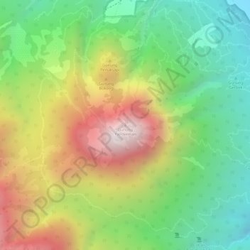
Name: Gunung Panderman topographic map, elevation, terrain.
Location: Gunung Panderman, Batu, East Java, Java, 65316, Indonesia (-7.90261 112.49764 -7.90251 112.49774)
Average elevation: 1,543 m
Minimum elevation: 1,143 m
Maximum elevation: 2,038 m
Thank you for supporting this site ❤️
Make a donation
Make a donation
Other topographic maps
Click on a map to view its topography, its elevation and its terrain.