
Make a donation
Yonne topographic map
Click on the map to display elevation.
Make a donation
Yonne
The geology of the department is complex with concentric rings of granite, Jurassic, Cretaceous and Tertiary rocks, and layers of sedimentary rocks. The terrain is mostly a low-lying plateau used for agriculture. The southwestern part is the Puisaye, which has a higher elevation and is more wooded. To the centre and east, the land inclines to the northwest where the higher land of the Tonnerrois region lies. To the east the rock is mostly limestone. The Auxerrois region is renowned for the grapes grown here, which are used in the production of Chablis wine. To the south lies the mountainous massif of Morvan, the highest parts of which are in the neighbouring department of Nièvre. The department has some forested areas but is mainly used for pasture or cultivated for wheat.
Make a donation
About this map
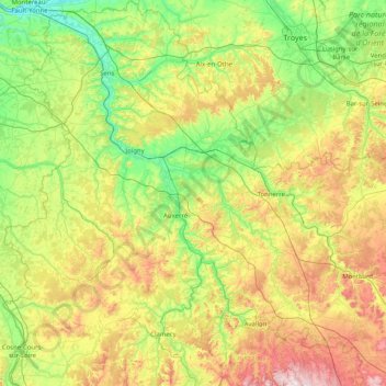
Name: Yonne topographic map, elevation, terrain.
Location: Yonne, Bourgogne-Franche-Comté, Metropolitan France, France (47.31036 2.84849 48.40006 4.34007)
Average elevation: 207 m
Minimum elevation: 45 m
Maximum elevation: 623 m
Make a donation