
Thank you for supporting this site ❤️
Make a donation
Make a donation
Perry City topographic map
Click on the map to display elevation.
Thank you for supporting this site ❤️
Make a donation
Make a donation
About this map
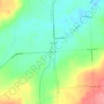
Name: Perry City topographic map, elevation, terrain.
Location: Perry City, Schuyler County, New York, 14886, United States (42.47202 -76.71467 42.51202 -76.67467)
Average elevation: 330 m
Minimum elevation: 292 m
Maximum elevation: 399 m
Thank you for supporting this site ❤️
Make a donation
Make a donation
Other topographic maps
Click on a map to view its topography, its elevation and its terrain.
Thank you for supporting this site ❤️
Make a donation
Make a donation
Lamoka Lake
United States > New York > Schuyler County > Town of Tyrone > Weston
Average elevation: 351 m
Burdett
United States > New York > Schuyler County > Burdett > Town of Hector
Average elevation: 284 m