
Grinde topographic map
Interactive map
Click on the map to display elevation.
About this map
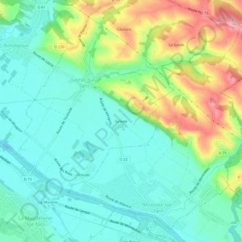
Name: Grinde topographic map, elevation, terrain.
Average elevation: 133 m
Minimum elevation: 89 m
Maximum elevation: 226 m
Other topographic maps
Click on a map to view its topography, its elevation and its terrain.
Tarn
France > Occitanie > Haute-Garonne > Layrac-sur-Tarn
Tarn, L'Escalaire, Layrac-sur-Tarn, Toulouse, Haute-Garonne, Occitanie, France métropolitaine, 31340, France
Average elevation: 106 m