
Make a donation
Uturuncu topographic map
Click on the map to display elevation.
Make a donation
Uturuncu
At an elevation of 6,008 metres (19,711 ft), Uturuncu is the highest mountain in southwestern Bolivia. It dominates the regional geomorphology, rising about 1,510–1,670 metres (4,950–5,480 ft) above the surrounding terrain and presenting a good view of the surrounding mountains from the summit. The volcano has two summit peaks, one 5,930 metres (19,460 ft) and the other 6,008 metres (19,711 ft) high. They are about 1 kilometre (0.62 mi) apart and separated by a saddle that is 5,700 metres (18,700 ft) high. Uturuncu is a stratovolcano with remnants of a crater, and consists of lava domes and lava flows erupted from a number of vents in the central part of the volcano.
Make a donation
About this map
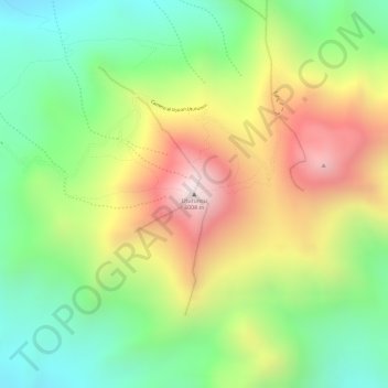
Name: Uturuncu topographic map, elevation, terrain.
Average elevation: 5,594 m
Minimum elevation: 5,259 m
Maximum elevation: 6,006 m
Make a donation
Other topographic maps
Click on a map to view its topography, its elevation and its terrain.
Morning Sun
Bolivia > Potosí > Provincia Sur Lípez > Municipio San Pablo de Lipez
Sol de Mañana is an area with geothermal manifestations in southern Bolivia, including fumaroles, hot springs and mud pools. It lies at about 4,900 metres (16,100 ft) elevation, south of Laguna Colorada and east of El Tatio geothermal field. The field is located within the Eduardo Avaroa Andean Fauna National…
Average elevation: 4,894 m
Laguna Salada
Bolivia > Potosí > Provincia Sur Lípez > Municipio San Pablo de Lipez
Average elevation: 4,390 m
Laguna Colorada
Bolivia > Potosí > Provincia Sur Lípez > Municipio San Pablo de Lipez
Average elevation: 4,302 m