
Thank you for supporting this site ❤️
Make a donation
Make a donation
Sunny Beach topographic map
Click on the map to display elevation.
Thank you for supporting this site ❤️
Make a donation
Make a donation
About this map
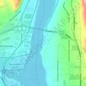
Name: Sunny Beach topographic map, elevation, terrain.
Location: Sunny Beach, Douglas County, Washington, United States (47.46651 -120.31502 47.46718 -120.31463)
Average elevation: 220 m
Minimum elevation: 185 m
Maximum elevation: 362 m
Thank you for supporting this site ❤️
Make a donation
Make a donation
Other topographic maps
Click on a map to view its topography, its elevation and its terrain.
East Wenatchee Bench
United States > Washington > Douglas County > East Wenatchee
Average elevation: 296 m